India is a vast country,lying entirely in the Northern hemisphere.
The main land extends between latitudes 8°4'N and 37°6'N and longitudes 68°7'E and 97°25'E.
The main land extends between latitudes 8°4'N and 37°6'N and longitudes 68°7'E and 97°25'E.
South of about 22° north latitude, it begins to taper, and extends towards the Indian Ocean,
dividing it into two seas, the Arabian Sea on the west and the Bay of Bengal on its east.
dividing it into two seas, the Arabian Sea on the west and the Bay of Bengal on its east.
The Tropic of Cancer (23° 30'N) divides the country into almost two equal parts.
In India Tropic of Cancer passes through 8 states. Rajasthan, Gujarat, Madhya Pradesh,
Chhattisgarh, Jharkhand, West Bengal, Tripura and Mizoram.
In India Tropic of Cancer passes through 8 states. Rajasthan, Gujarat, Madhya Pradesh,
Chhattisgarh, Jharkhand, West Bengal, Tripura and Mizoram.
The latitudinal and longitudinal extent of the mainland is about 30°.
From Gujarat to Arunachal Pradesh, there is a time lag of two hours. Hence, time along the
Standard Meridian of India (82°30'E) passing through Mirzapur (in Uttar Pradesh) is taken
as the standard time for the whole country.
Standard Meridian of India (82°30'E) passing through Mirzapur (in Uttar Pradesh) is taken
as the standard time for the whole country.
India is the seventh largest country of the world.The land mass of India has an area of
3.28 million square km. India’s total area accounts for about 2.4 per cent of the total
geographical area of the world.
3.28 million square km. India’s total area accounts for about 2.4 per cent of the total
geographical area of the world.
India has a land boundary of about 15,200 km and the total length of the coastline of the mainland,
including Andaman and Nicobar and Lakshadweep is 7,516.6 km.
including Andaman and Nicobar and Lakshadweep is 7,516.6 km.
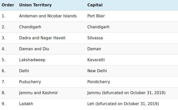
India has 29 states and seven Union Territories
India shares its land boundaries with Pakistan and Afghanistan in the northwest, China (Tibet),
Nepal and Bhutan in the north and Myanmar and Bangladesh in the east.
Nepal and Bhutan in the north and Myanmar and Bangladesh in the east.
Our southern neighbours across the sea consist of the two island countries Sri Lanka and
the Maldives.
Sri Lanka is separated from India by a narrow channel of sea formed by the Palk Strait and
the Gulf of Mannar, while Maldives Islands are situated to the south of the Lakshadweep Islands.
the Maldives.
Sri Lanka is separated from India by a narrow channel of sea formed by the Palk Strait and
the Gulf of Mannar, while Maldives Islands are situated to the south of the Lakshadweep Islands.
In India, the states of Jammu and Kashmir (J&K), Himachal Pradesh, Sikkim, Uttarakhand and
Arunachal Pradesh share their borders with China.
Arunachal Pradesh share their borders with China.
The Indian states that touch the border with Nepal are Bihar, Uttar Pradesh, Uttarakhand,
West Bengal and Sikkim.
West Bengal and Sikkim.
The Indian states of West Bengal, Arunachal Pradesh, Sikkim and Assam share their borders
with Bhutan. The Kingdom of Bhutan and the Republic of India are divided by an international
boundary that is about 699 km long.
with Bhutan. The Kingdom of Bhutan and the Republic of India are divided by an international
boundary that is about 699 km long.
Four Northeast Indian states share the border with Myanmar: Arunachal Pradesh, Nagaland,
Mizoram, and Manipur.
Mizoram, and Manipur.
(i)Lakshadweep Islands lie in the Arabian Sea.
(ii)Russia, Canada, USA, China, Australia and Brazil are the countries that are larger than India.
(iii)Andaman and Nicobar Islands lie to the South-East of India.
(iv)Sri Lanka and the Maldives are the two island countries that are the Southern neighbours of India.
The number of Union Territories along the western and eastern coasts.
Union Territories on the western coast of India are — Diu and Daman, Dadra and Nagar Haveli,
Mahe (Pondicherry) and Lakshadweep.
Mahe (Pondicherry) and Lakshadweep.
Union Territories on the eastern coast of India are — Pondicherry and Andaman and Nicobar Islands.
Area-wise which is the smallest and which is the largest state?
Largest State: Rajasthan
Smallest State: Goa
The states which do not have an international border or lie on the coast.
Haryana, Madhya Pradesh, Chhattisgarh, Jharkhand, Telangana.
• Classify the states into four groups each having common frontiers with
(i) Pakistan, (ii) China, (iii) Myanmar, and (iv) Bangladesh.
(i) States having common frontiers with Pakistan are Jammu and Kashmir, Punjab, Rajasthan,
Gujarat.
Gujarat.
(ii) States having common frontiers with China are Jammu and Kashmir, Himachal Pradesh,
Uttarakhand, Sikkim and Arunachal Pradesh.
(iii) States having common frontiers with Myanmar are Arunachal Pradesh, Nagaland, Manipur,
Mizoram.
Mizoram.
(iv) States having common frontiers with Bangladesh are Meghalaya, Assam. West Bengal,
Tripura.
Tripura.
References : NCERT _CONTEMPORARY INDIA - I @ INTERNET

No comments:
Post a Comment